SLOs (Significant Landscape Overlays)
What is Mitchell Shire Council proposing?
Mitchell Shire Council is proposing to impose new Significant Landscape Overlays (SLOs) that will affect more than 400 properties, and almost 10% of the land in the Mitchell Shire, with 94% zoned “Farming”.
These SLOs will impose new restrictions on farmers, adding burdensome bureaucracy, increased costs, and other potentially serious negative and unintended consequences.
What is a Significant Landscape Overlay (SLO)?
A Significant Landscape Overlay (SLO) is the planning tool used by Victorian councils for protecting and managing significant landscapes. Its stated purpose is to identify significant landscapes, and conserve and enhance their character.
A significant landscape is defined by the Victorian government1https://www.planning.vic.gov.au/guides-and-resources/guides/all-guides/south-west-landscape-assessment-study as one that is ‘special or important due to its cultural landscape values, including aesthetic values (both visual and non-visual), historic, environmental, scientific, social, or other values.’
This is open to subjective interpretation and doesn’t specifically consider agricultural land use.
What has been the process?
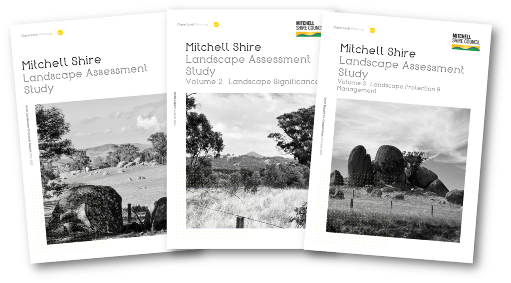
Landscape Assessment Study (LAS)
Mitchell Council engaged Claire Scott Planning, an external firm, to conduct the Landscape Assessment Study. The study was conducted between March 2020 and May 2024 using a methodology developed by Claire Scott Planning’s principal, Claire Scott. Notably, this methodology has been criticized by the Victoria Planning Panel for not referencing any established guidelines or industry standards.
The study prioritizes views and vistas, considering agriculture and primary production relevant only in the context of scenic landscapes. It recommends new permit restrictions that impact agricultural activities, yet fails to provide any impact assessment for these recommendations.
The Landscape Assessment Study consists of three volumes:
"Consultation"
Mitchell Council conducted a process it describes as “consultation” about the Landscape Assessment Study and the proposed SLOs.
However, their consultation was deeply problematic.
- Many directly affected landowners were unaware of the proposals
- Feedback from environmental groups and supportive submissions (only 2 of which were from directly impacted landowners) were amplified
- Groups with strong farming associations eg Victoria farmers Federation and Landcare were not consulted
- Feedback from directly impacted landowners was minimised and downplayed.


Endorsement of the Landscape Assessment Study
On August 19, 2024, Mitchell Council narrowly endorsed the Landscape Assessment Study (LAS) with a close 4-3 vote. This endorsement proceeded despite a flawed consultation process and sustained community opposition. The approval was subject to several last-minute conditions that seem more like superficial attempts to placate concerned landowners, introducing further uncertainty rather than addressing the core issues.
You can view the livestream recording of the Council meeting (commencing at 55:43)
New Conditions Introduced by Endorsement
The resolution to endorse the Landscape Assessment Study was amended at the last minute to include several conditions. Councillor Fiona Stevens claimed these conditions addressed farmers’ concerns, stating:
“The points that I've raised in this amendment are exactly their [farmers'] concerns.”
Wrong!
The amendments reflect a fundamental misunderstanding of our concerns and demonstrate a superficial attempt to appease us without genuine engagement.
Major Issues With Council's Endorsement
Contradictory amendments: Last-minute changes are
illogical and fail to resolve key issues.
Selective exemptions: Native vegetation permit clause
to now link to 2 exemptions but excludes at least 16 others including grazing
and emergency works
Misguided benchmarking: Benchmarking study undermines
the specific needs of diverse farms.
Vague permit guidelines: New language on agricultural
activity lacks clarity and precision.
Undermined process: Endorsing the LAS before addressing consultation flaws and impact assessments undermines the entire process.
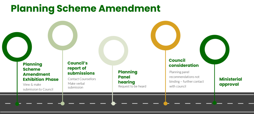
What happens now?
The process to amend the Mitchell Planning Scheme to introduce the new Significant Landscape Overlays (SLOs) is lengthy and will include an Independent Review and Victoria Planning Panel hearing for any objections which are not resolved by Council.
Council’s conditional endorsement included extra steps including a “benchmarking study” and an “impact assessment”. Council has added extra steps including a “benchmarking study” and “impact assessment”. We are concerned that the process will take years, absorbing endless time and scarce resources.
Protect Our Farms will remain actively involved at every stage, ensuring that the voices of farmers are heard and advocating against changes that prioritize views over agricultural livelihoods.
Which areas are covered by the SLOs?
Council is proposing three new SLO areas:
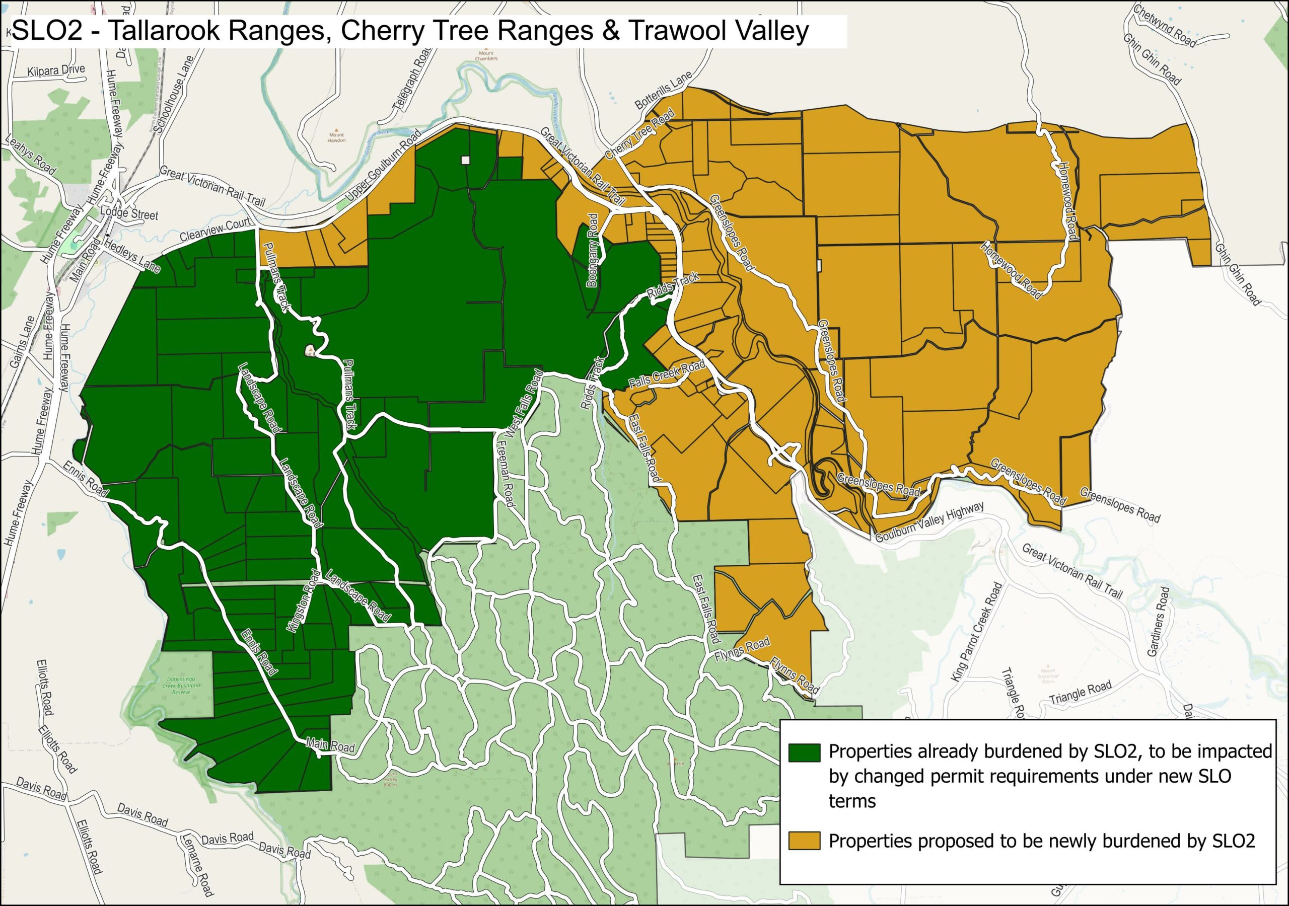
Tallarook Ranges, Cherry Tree Ranges & Trawool Valley
SLO2: AREA AND PERMIT REQUIREMENTS BOTH CHANGING
Council is planning to more than double the existing Tallarook Ranges SLO to cover almost 12,000 hectares of land. Almost all of the land to be included is privately owned farming zone land.
The new SLO is very different to the existing SLO imposing new permit requirements which will dramatically impede farming operations.
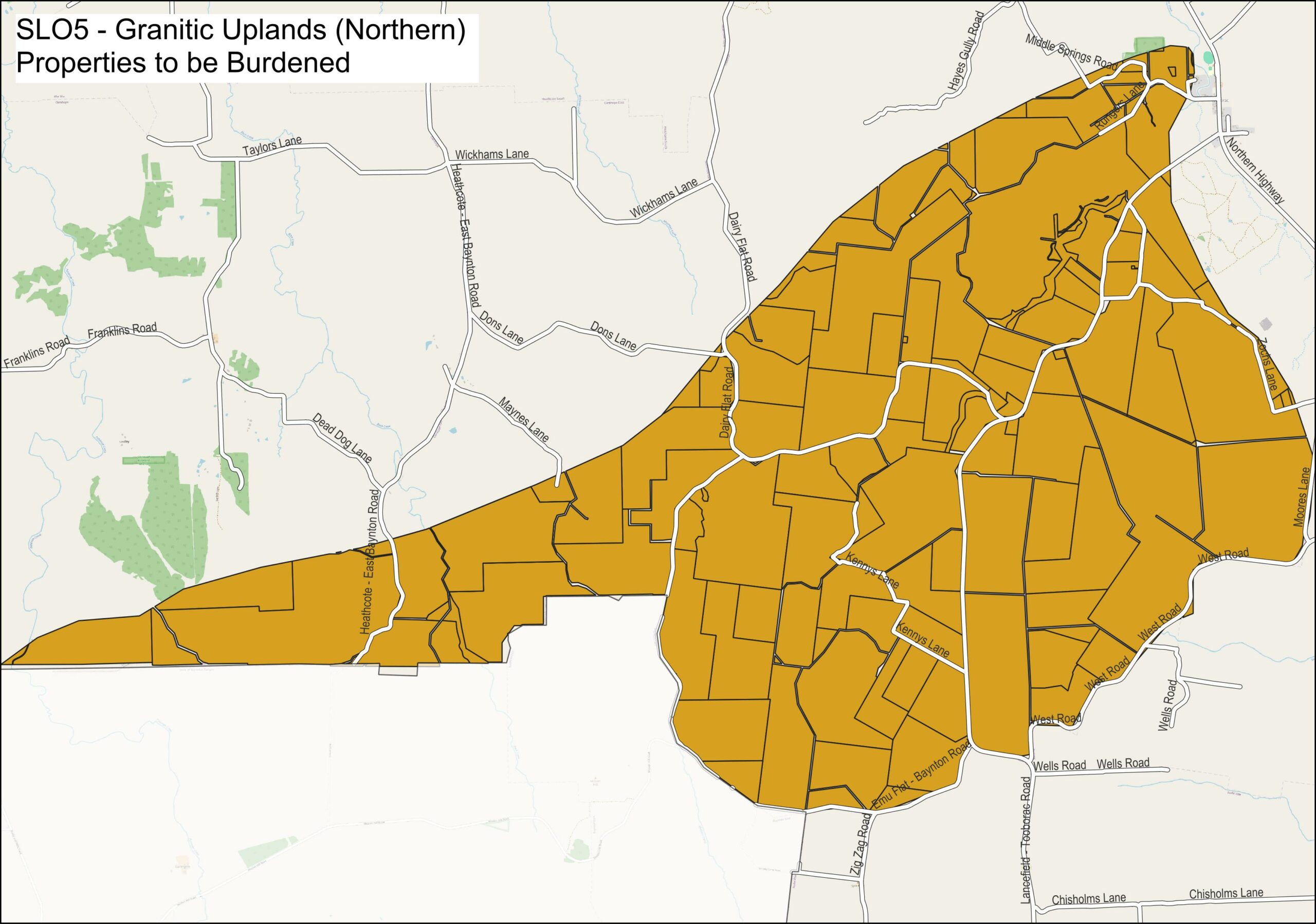
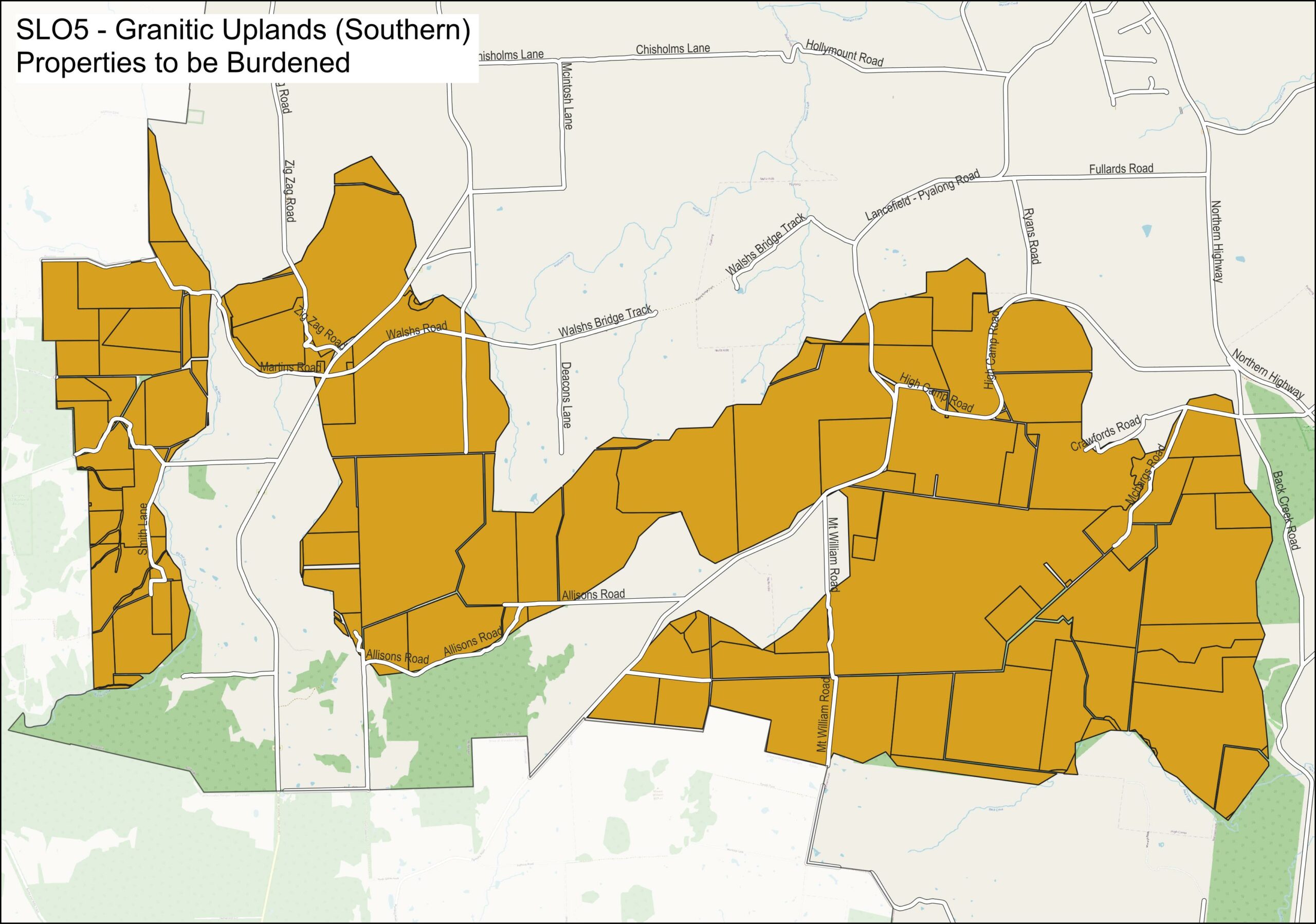
Granitic Uplands – Tooborac and Pyalong
SLO5: NEW AREA AND PERMIT REQUIREMENTS
Council is proposing a new SLO across the Tooborac / Pyalong area covering almost 13,000 hectares. 97% of this land is privately owned farming zone land.
Landholders at Tooborac and Pyalong who are burdened by the SLO will face permit requirements that will dramatically impede farming operations.
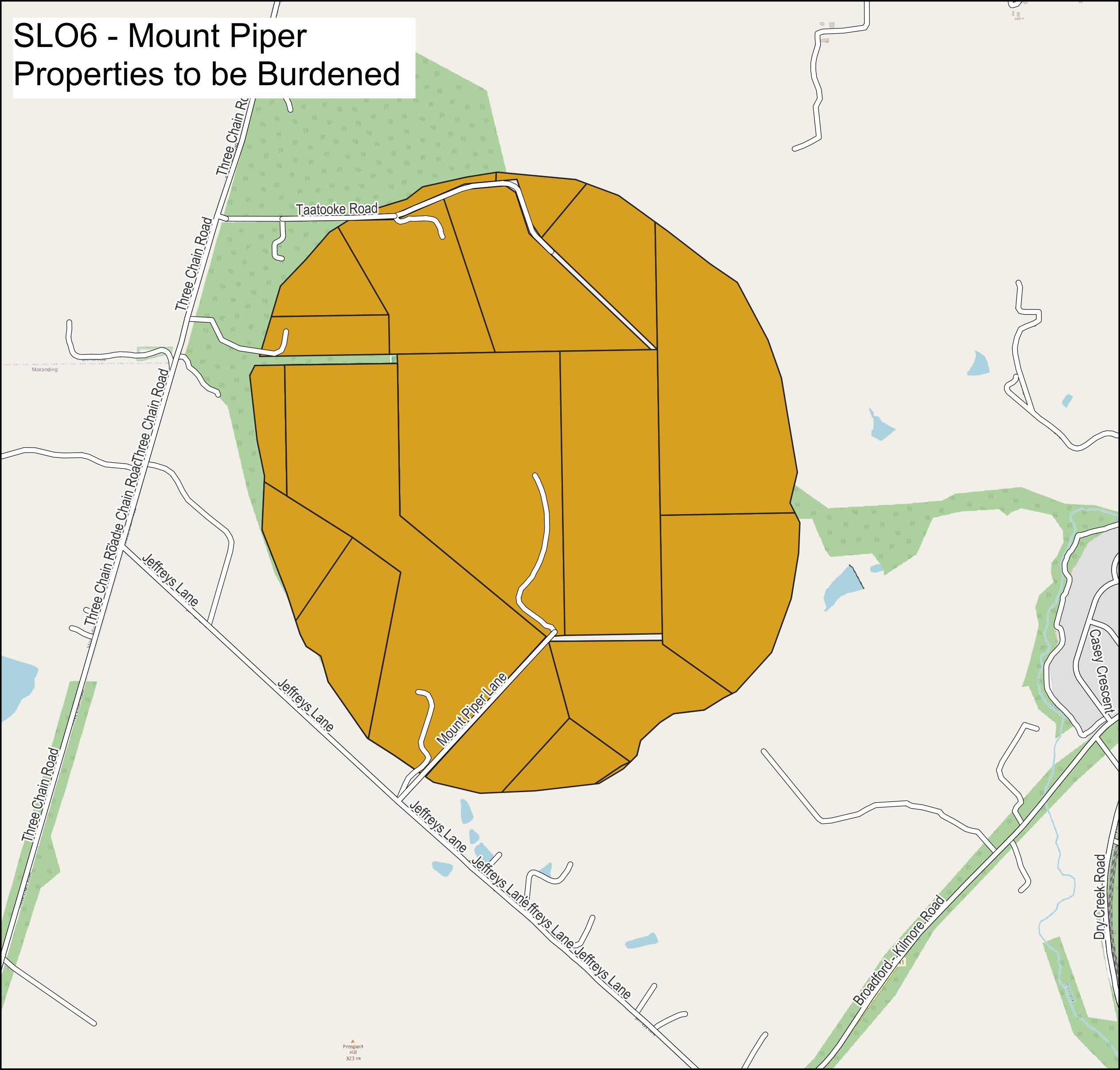
Mount Piper
SLO6: NEW AREA AND PERMIT REQUIREMENTS
At Mount Piper the SLO is proposed to cover almost 400 hectares. While most of the area to be covered is already protected via zoning as ‘Public Conservation Rural Zone’, a quarter of this SLO area is comprised of privately owned farming zone land.
Landholders at Mount Piper who are burdened by the SLO will face permit requirements that will dramatically impede farming operations.
What activities will require a permit under the proposed SLOs
The best way to understand the impact of the SLOs is to read the “Permit Requirement” section at part 3 of each SLO which you can view at the following links.
Or keep scrolling and you’ll find an overview of the permit requirements compared to the far less restrictive requirements contained in current SLOs.
Mitchell already has a 4 SLOs. 3 are very small and mostly cover public land. One of the existing SLOs, SLO2 at Tallarook Ranges, is proposed to be more than doubled in size.
A comparison of the terms of the existing SLO2 with the proposed SLO2 shows how restrictive the proposed permit requirements are.
Proposed SLO (unworkable)
Contrast to requirements for existing SLOs (workable for farmers)
A permit is required to remove, destroy, or lop any native vegetation.
A permit is not required for removal, destruction or lopping of dead vegetation, exotic vegetation or native vegetation if seedlings or regrowth are less than 10 years old and the land is being re-established or maintained for cultivation or pasture, the minimum extent of native vegetation necessary for the construction, operation or maintenance of a fence, or the removal, destruction or lopping of native vegetation as a result of grazing domestic stock or moving stock along a road.
A permit is required to construct a fence, except for:
- A post and wire fence up to 1.8 metres in height.
- A fence below 1 metre in height.
- Livestock yard fencing
A permit is not required for:
- A water tank.
- Construction of a farm access track
A permit is not required for any agricultural development or activity, including cultivation, dam, fencing, water tanks and water bores.
A permit is not required for :
- An alteration or extension to an existing dwelling up to 100 square metres in floor area, provided it does not increase the overall height of the building.
- A building used for agriculture or an alteration or extension to a building used for agriculture where all the following are met:
- The building is constructed using external materials and finishes that minimise its visibility in the landscape, such as natural timber, subdued colours, or galvanised iron;
- the total floor area of the buildings is no more than 200 square metres;
- the building is single storey and no more than 5 metres in height above natural ground level; and,
- the building is not sited on a ridgeline, or on the upper slopes of a hill face so that it protrudes above a ridgeline
A permit is not required for:
-
Any alterations or additions to an existing dwelling or outbuilding, provided the proposed building is not within 100 metres of a waterway, the slope of the land is less than 15 per cent, the proposed floor area is not greater than 100 per cent of the existing floor area, there is no increase in building height, all external building materials are of nonreflective materials, no removal of native trees or shrubs is required, and earthworks are less than 2,000 square metres, to the satisfaction of the responsible authority.
A permit is not required for:
- A building used for agriculture or an alteration or extension to a building used for agriculture that is an open-sided rural structure.
A permit is not required for Development of an outbuilding of less than 120 square metres in floor area (and where the total floor area of all outbuildings does not exceed 200 square metres), the slope of the land is less than 15 per cent, no removal of native trees or shrubs is required, earthworks are less than 2,000 square metres and the development site is not within 100 metres of a waterway, to the satisfaction of the responsible authority.